Thursday 29th March 2018
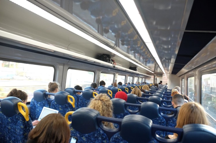
We took a train right after work from Sydney Central station to Katoomba at 5.51pm. We got there 2 hours later and walked to the hotel we had booked.
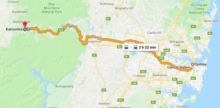
Here is a map of the train ride, the Blue Mountains being really west of Sydney.
Friday 30th March 2018
In the morning, we walked through the Street Art Walk area started in June 2015, in which there was beautiful street art on the walls. We bought some sandwiches for lunch from the beautiful Hominy bakery. Then we walked to a shop where we confirmed our bus tickets to Jenolan Cave and waited for the 10.15am bus. Most people waiting for the bus were hikers who were also going to hike the Six Foot Track from Jenolan back to Katoomba.
")
")
")
")
")
")
")
")
")
")
We boarded the bus which took us to the Jenolan Caves. Most hikers left straight to the hike, while we visited first the Lucas Cave then the Imperial Cave. The Jenolan caves were discovered by white settlers in 1838 when James and Charles Whalan were chasing a convict James McKeown who had gone in them to hide. The caves have been known for thousands years by the Aboriginal people living there and are part of the Gundungurra Country. A Gundungurra story tells how the river valley and the caves -known as Binnomur (or Binoomea) were created during a fierce struggle between two giant creatures. The Wiradjuri people also have an interest in the area. When the Whalan brothers explored the caves, they were named the Fish River Caves then Binda or Bindo caves then the Jenolan Caves. Jenolan is considered among the best decorative and most complex cave system in the world and it was definitely great to take the tours between 1pm and 4pm and see two of the 15 caves which can be visited!
")
")
")
")
")
")
")
")
")
")
")
")
")
")
")
")
")
")
")
After the caves, we picked up our hiking packs, left the Jenolan Caves and started on the hiking trail of the Six Foot Track, whoohooo!!! During the 19th century, the Jenolan Cave started being a touristy destination but was hard to reach. The Six Foot Track was created in 1884 to accommodate horses pulling carriages and shorten the long journey to 8 hours to the caves. It was used mostly until 1915. In 1984, it was decided to re-open it as a hiking trail.
Here we were, finally hiking the most famous 3-day hike of the Blue Mountains. We knew we only had about 2.5 hours of light left to hike and considered I am the slowest hiker in the world, that meant we would not make it to the first campground available which is 10 kilometers from the Jenolan Caves but would have to stop at the 5-6 km mark. It meant we would have to bush camp somewhere which I had confirmed with the National Park on the phone is allowed on that track.
We had taken 5 litres of water each to be safe, so we could drink in this hot water as much as needed, and have water to cook and make tea in the evening and morning. On our way, we passed the Binda Flats lodges. Maybe 45-min walk after the lodges, we decided to pitch the tent as there was only 30 minutes of light left. The problem was that there was only bush around the trail, so we had to…pitch the tent directly on the path itself!
")
")
")
")
")
")
")
")
")
")
Saturday 31st March 2018
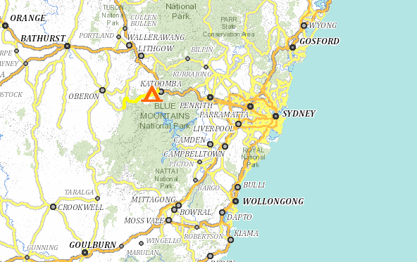
Here is a map of where the Six Foot Track lies in the grand scheme of the Blue Mountains. It is actually more on the edge of it, going through the Megalong Valley than really inside the Blue Mountains.
Zoomed Out
Zoomed In
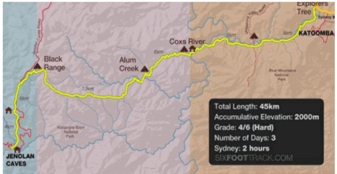
Another map of the track found on the website dedicated to that hike:
http://www.sixfoottrack.com/
More info about the hike here:
http://wildwalks.com.au/bushwalking-and-hiking-in-nsw/blue-mountains-katoomba/six-foot-track-alum-creek-reserve.html
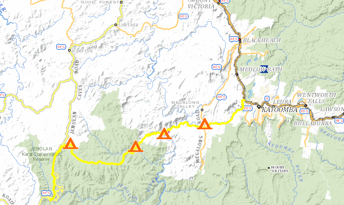
Here is a map of the hike for what we did on Day 1 and Day 2:
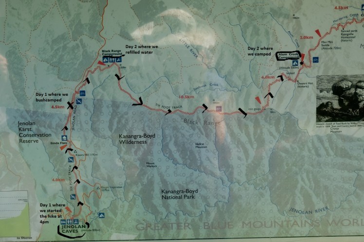
I had a hard time sleeping because a leech kept crawling up on the outside of the tent and trying to get inside the tent from the side, which was really not a nice thing to see in the middle of the night! I found the culprit still on the tent canvas in the morning.
We woke up around 6.30am when 5 hikers passed by our tent, probably people who had stayed at the nearby Binda Flats lodges. The fog surrounding us created a quite airy atmosphere. We unpacked the tent first as it was right in the middle of the path, then boiled some water which we poured onto cereals with an ounce of cinnamon and dried fruits in for brekky. Then we started walking around 9am and arrived at the Blackmore Campground around 10.30am. On our way there, we saw mushrooms, crickets, yellow-tail black cockatoos. We also saw one ant carrying another one alive which seemed to be resisting. We separated them and each went its own way. Strange.
When we arrived at the campground, we needed to refill our bottles for water for the long day-hike ahead of us as we were running low. At that stage, one guy came to us carrying a massive Pureau 10L box and said: ‘I am about to jump on my motorbike to head back home. Would you guys want the rest of the water in it?’ We said ‘Sure, ok!’ And refilled our bottles with purified water instead of the tank’s water. Surreal but nice!
")
")
")
")
")
")
")
")
")
")
")
")

")
")
We left Blackmore Campgrounds and continued our hike all the way to Alum Creek Campground, which was 20 kilometers from the spot where we had slept the previous night. We took a 30-min break in the middle of the track for some lunch at some point. We saw cool little birds and ants, lezards and termite mounds. Some ultrarunners passed us who had started at dawn in Katoomba and were carrying ultra-runners diamond bags on their back filled only with water and a few snacks. They were doing the entire 45km in one day. Whoo. Like in the ‘Born to run’ book!!! Fascinating. We also saw motorbikes, bicycles and other hikers. We finally got to Alum Creek Campground and pitched our tent there, then walked back 10 minutes to have a shower in the little stream with the Wilderness wash liquid eco-wash and microfibres, and also refilled our bottles with water. In the evening, it was great to share the 2 tables with other hikers and car drivers / hikers. Some were from the area around Chinchilla, which is 5 hours North-West of Brisbane and told us fun stories about the watermelon festival taking place each year in February there. It does sound like a funny one! http://melonfest.com.au/
")


")
")
")
")
")
")
")
")
")
")
")
")
")
")
")
")
")
")
")
")
Next day, off all the way to the Megalong Cemetery campground!
